
Accumulating Snow Headed Our Way
- Feb 3, 2020
- 3 min read

West Texas will get its first shot at seeing accumulating snow starting Tuesday night. In the photo above, the blue counties have a winter storm watch from noon Tuesday, through 6:00 pm Wednesday. A watch means we are waiting and watching for potential winter weather impacts; including accumulating snow and some sleet. I would be surprised if this changes by tomorrow. I believe the first areas capable of seeing a winter storm warning would be southeast of Lubbock, off the Caprock. This is obviously something I will watch Tuesday and Wednesday.


The big issue with the system is how far the forecasts differ, even at this point. The above photos are two different computer forecasts that I use on a daily basis. The one on the left is actually the GFS, which has the bias of over-predicting precipitation. The one on the right is the NAM, which is not very good in forecasting anything in west Texas. I usually take this one with a grain of salt. But you can see that, at basically the same time, the forecast is changing from low amounts, to heavy snow for everyone. For this storm, I am not going to side with the NAM, the one on the right. Here's why. The GFS, on the left, and the Euro forecast are now lining up more and essentially showing the same forecast. The Euro, which is more accurate at predicting precipitation events, is starting to push the heaviest snow east and southeast of Lubbock. It's not as far to the southeast as the GFS, but it is close during the same time period. That is the reason I believe the heaviest snow and most accumulation will miss Lubbock and will stay off the Caprock.

Here is a look at that European Model (Euro) for the time period of midnight-6:00 am Wednesday. It is lining up really close to what the GFS model was showing. It is showing the heaviest precipitation staying well east of the area. As a forecaster, you're taught to take these models with some doubt. Remember, these are just computers. Information is being fed into them by humans. Errors occur often. However, when several of them are starting to reflect the same thing, you really start to see the pattern. That is a good indicator of what is likely to happen. These models are never 100% correct. Remember a few posts ago about the icy weather that most computers were calling for on two separate occasions in January. Most models were showing a lot of ice for our area. I sided with the Euro and a few others that were showing far less, or nothing. Obviously we know nothing happened. You really need to look at all information available and look at the dynamics and ingredients available for each individual storm. Forecasting snow in west Texas is extremely difficult as you can see from these three models posted above.
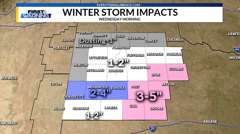
After looking at the nine different computer forecast and all information available, the above photo is what I believe the forecast till be by Wednesday morning. Areas east and southeast of Lubbock will get some heavy bands of snow and will have the highest probability of receiving the highest accumulations. I would not be surprised if a winter storm warning is issued for those pink areas by tomorrow afternoon. Denver City, Brownfield and Tahoka have the potential to see 2-4" of snow. Lubbock is now forecast to receive 1-2". Even to inches of snow will cause slick spots on the roads, which will lead to numerous accidents. You really need to be careful out on the roads early on Wednesday. This storm will move out of Lubbock by noon Wednesday and by 3:00 pm in the eastern counties.
This is obviously a fluid situation and the forecast will change by tomorrow with new information coming in. As of now, I would even say that by tomorrow, Lubbock, to Tulia, to Tahoka and west may see lower amounts of snow. But we do need to prepare for accumulating snow late Tuesday night, into Wednesday morning. It will all depend on the speed and track of this low coming in from the Rockies.
Comments