
Interesting Weather To End The Year
- Dec 29, 2020
- 3 min read

2020 sure has been a strange year overall. However, the weather in west Texas really hasn't been exciting for about the last six months. Dry air has won out and we are in an unfortunate drought situation. With that said, light precipitation is in the forecast for the region starting today. The type of precipitation that will fall today will be liquid. Temperatures will remain above freezing and will actually get into the low 60s for most this afternoon. A strong cold front will move in tonight, bringing in much colder air to end the year.
This precipitation forecast has changed over the last two days, but has come into more agreement as of Tuesday morning. Expect drizzle, or light rain for Lubbock and locations to the north and west. The best shot for a few showers, or even rumbles of thunder, will be northeast of Lubbock. Total accumulation of rain today will remain light.
As the cold front advances through tonight, a potent upper-level low pressure system will drag in very cold air. Lubbock will see the temperature drop to near freezing by 4:00-6:00 am Wednesday. The air will be colder to the north, where freezing rain is possible. The photo above is the forecast model for midnight-6:00 am Wednesday. It doesn't show a whole lot happening, as precipitation will remain light. There will be a mix of rain and snow, with some sleet for Lubbock and areas west. There will mainly be rain off the Caprock, with some freezing rain possible especially after 4:00 pm. Remember, amounts of precipitation will be light.

A mix of rain, snow, sleet and some freezing rain will continue for Lubbock and areas west after sunset Wednesday, through Thursday morning. There will be mainly rain off the Caprock, with some snow and freezing rain mixed in, especially Thursday morning. Amounts of precipitation will stay on the lighter side. Snow will begin after sunset Wednesday FOR ONLY THESE THREE COUNTIES: Dawson, Borden and Scurry. Those counties will see accumulating snow from Wednesday evening through Thursday evening. The picture above is the forecast for 6:00 am-noon on Thursday. This shows some heavy snow falling in the Permian Basin, where 6-10" of snow is possible by Thursday evening.
A mix of rain, snow and sleet will be possible Thursday morning for Lubbock and counties west. A rain snow mix can be expected off the Caprock, with the accumulating snow in Dawson, Borden and Scurry Counties. Freezing rain accumulations will only occur across Parmer, Castro, Swisher and Briscoe Counties by midday Thursday. So be careful driving in those three counties.

Wrap around precipitation can't be ruled out New Year's Eve. The photo above is the computer forecast for midnight-6:00 am on New Year's Day. It is showing all snow off the Caprock, stretching back to Lubbock County. Now, this is just a computer forecast. Analysis of data is indicating some leftover flurries, or very light freezing rain for the central and eastern counties (including Lubbock) New Year's Eve, through 6:00 am on New Year's Day. As the trend has been, precipitation will be light, with no accumulations. Flurries or freezing drizzle will be the main type of precipitation, so there's nothing to worry about there. The precipitation will end by Friday morning at 6:00 am.

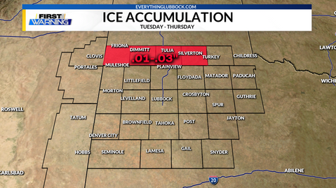


To reiterate my point about light precipitation, the phots above are the current forecast for ice (on the left) and snow (on the right). A lot of people will ask, what about Lubbock, what about Levelland, what about Floydada, etc. Well, it is great to get a map an know where your county and town is located. It's so much easier to show these maps and explain where the accumulations are to focus on these areas, then locations that won't see any accumulation.
In terms of ice accumulation, watch for .01-.03" possible across Parmer, Castro and Swisher Counties from Wednesday-Thursday mornings. The rest of us will see only light precipitation, with no major issues. Slick spots from ice will only occur in Parmer, Castro and Swisher Counties. For snow, the only counties that will see accumulating snow will be Dawson, Borden and Scurry where 2-4" will be possible from Wednesday evening, through Thursday evening. If you're lucky, you may see a light dusting on grass for Lubbock and our central counties. But I wouldn't really count on that.
If anything changes in the forecast, I will be sure to post another update. Thank you so much for reading this.
Comments